
 Italiano
 Deutsch
2023/03/06 11:30:38
Kamenjak
Author

Place
Croatia
Km
17,32 km
Elapsed time
-416236:-49:-5
Vertical meters
+110 mt (0 - 57)
Route difficulty
Landscapes
Last update
2023/03/07 11:56:11
Comments
Description
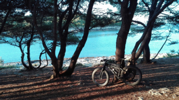
Short but very scenically beautiful itinerary, mostly on trails overlooking the sea.
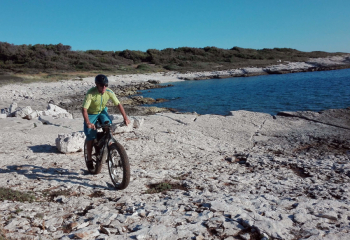
We start from the Stupice campsite and fira the peninsula counterclockwise, passing first on the dinosaur trail, then always as much as possible along the coast , arriving on the southernmost point with a beautiful view of the islands, then climbing up, passing through beautiful pine forests and a few challenging trails, always with magnificent views, passing the small village of Premantura and back through the woods again towards the campsite.
Local weather

°C
°C
°C
°C
°C
°C
Graph
Nearest Routes
39,90 km
Km
+120 mt
Vertical meters
Route difficulty
Landscapes
35,84 km
Km
+150 mt
Vertical meters
Route difficulty
Landscapes
39,70 km
Km
+220 mt
Vertical meters
Route difficulty
Landscapes
34,59 km
Km
+200 mt
Vertical meters
Route difficulty
Landscapes
34,74 km
Km
+120 mt
Vertical meters
Route difficulty
Landscapes
30,40 km
Km
+100 mt
Vertical meters
Route difficulty
Landscapes
30,07 km
Km
+90 mt
Vertical meters
Route difficulty
Landscapes
99,19 km
Km
+900 mt
Vertical meters
Route difficulty
Landscapes