
 Italiano
 Deutsch
2023/03/06 08:29:53
Gagliardo, Tre Dita, 301 da Punta Ala
Author

Place
Italy - Toscana, GR
Km
42,86 km
Elapsed time
04:02:25
Vertical meters
+1 000 mt (-12 - 512)
Route difficulty
Landscapes
Last update
2023/03/06 15:12:57
Comments
Hotels
Description
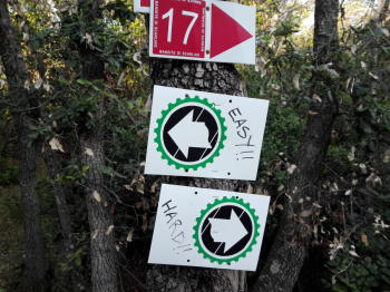
Three not long but challenging climbs and three fun but challenging descents on the Scarlino promontory.
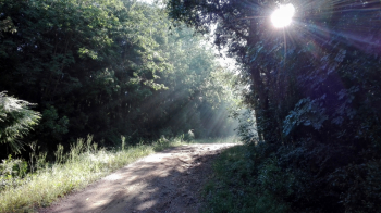
Best done early in the morning to avoid horseflies and stay cool. Trail condition is usually good, but depends on rainfall and when last maintained by good local volunteers.
Local weather
Fri 00:00

25 °C
Fri 12:00

32 °C
Sat 00:00

26 °C
Sat 12:00
32 °C
Sun 00:00
25 °C
Sun 12:00
33 °C
Graph
Nearest Routes
45,07 km
Km
+900 mt
Vertical meters
Route difficulty
Landscapes
41,79 km
Km
+910 mt
Vertical meters
Route difficulty
Landscapes
25,87 km
Km
+420 mt
Vertical meters
Route difficulty
Landscapes
33,05 km
Km
+820 mt
Vertical meters
Route difficulty
Landscapes
33,82 km
Km
+750 mt
Vertical meters
Route difficulty
Landscapes
48,74 km
Km
+1 100 mt
Vertical meters
Route difficulty
Landscapes
38,44 km
Km
+1 050 mt
Vertical meters
Route difficulty
Landscapes
2023/10/28
- Italy - Toscana, GR 63,43 km
Km
+813 mt
Vertical meters
Route difficulty
Landscapes
25,17 km
Km
+648 mt
Vertical meters
Route difficulty
Landscapes
10,48 km
Km
+382 mt
Vertical meters
Route difficulty
Landscapes